Tornado Danger is High as Severe Weather Scuttles the Southern United States
Through Thursday, severe storms bringing massive hail, flash flooding, tornadoes, and strong winds will move eastward over the southern United States. It’s expected that some of the tornadoes will happen after dark.
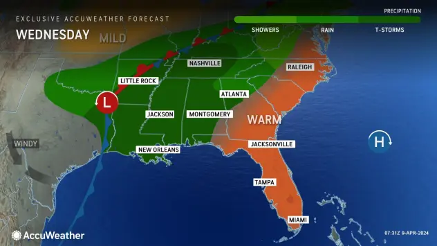
As a slow-moving storm system forms and intensifies, there will be a greater chance of severe weather, including the possibility of at least a few tornadoes, in the south-central United States on Wednesday afternoon and evening, AccuWeather meteorologists warn. Tornadoes can be dangerous because they might happen at night, which increases the risk.
The thunderstorm threat will move slowly eastward and then pick up speed toward the end of the week, accompanied by all forms of severe weather. Through Wednesday evening, there is a chance of strong winds, tornadoes, flash flooding, and baseball-sized hail.
Travel on the highways and on airlines will become more difficult as the storms move toward and through large Southern cities.

There is a significant risk of severe weather, including tornadoes, according to AccuWeather meteorologists, with the worst storms expected through Wednesday night. Cloud cover, together with competing showers and thunderstorms, temper the severe weather threat, although the level stays high.
On Monday, the only severe weather-related incidents were hail and strong winds that spanned from western Tennessee to northern and western Texas. In Wise County, Texas, there were almost forty hail reports, with large ice chunks the size of teacups among them.
Just after sunrise on Tuesday, thunderstorm activity in certain areas of Texas and northern Louisiana was already approaching severe levels. Throughout the day, the storms’ intensity will rise and fall before intensifying dramatically on Tuesday night.
“There will be a nocturnal tornado threat in parts of eastern Texas and western Louisiana,” senior meteorologist Tyler Roys of AccuWeather stated.

Torms are expected to erupt on Tuesday evening, moving eastward and northward from the vicinity of the Rio Grande to close to Dallas.
“Around and north of Houston, the threat for severe weather and tornadoes will be greatest after 4 a.m. local time on Wednesday,” Roys stated.
From Wednesday through Thursday, the threat of severe weather will start to concentrate along and ahead of an approaching cold front. The severity of Thursday’s severe weather in the Southeast will depend on the forward speed.
Along the Interstate 10 and 20 corridors, the potential of hail, tornadoes, and strong winds will move eastward over the day on Wednesday and into the evening.
The severe weather threat for Wednesday will stretch from just east of Houston, north to the Louisiana state line, east across Louisiana, through a large portion of Arkansas, and over most of Mississippi.
According to Roys, incidences of flooding, rain, and hail may be concentrated more toward I-20, while a large portion of the high winds and tornado risk may be concentrated closer to I-10.
The following major cities are at risk of severe weather on Wednesday: Jackson, Mississippi; Port Arthur, Texas; and New Orleans.
“Despite less-than-ideal atmospheric conditions on Wednesday, we believe the severe weather outbreak will produce double-digit tornadoes, and multiple tornadoes could be on the ground at the same time,” AccuWeather Chief On-Air Meteorologist Bernie Rayno stated.
There will still be strong thunderstorms, some of which have the potential to produce tornadoes on Wednesday night. Later on Wednesday night, there may be less risk of powerful tornadoes when the storms consolidate into a more stable line. As storms move eastward from Alabama to the Florida Panhandle and western Georgia, there can still be a few brief spin-ups and an increasing rush of intense wind gusts.
Wednesday night, there is a chance of severe weather in Atlanta, Pensacola, Alabama, and Mobile, Alabama.
On Thursday, the cold front linked to the severe weather will turn northeast and pick up speed throughout the East Coast.

Along the southern Atlantic Seaboard, the risk of severe weather will keep moving eastward. In parts of the Carolinas, northeastern Florida, and Georgia, storms may move out fast on Thursday morning. But with the afternoon heat from northeastern North Carolina to the mid-Atlantic, the threat might increase once more.
Read More News: The Parents of the Michigan School Shooter, Who Face Possible Jail Terms, Ask the Judge for Mercy

